| IMAGE |
IMAGE NO.
|
DATA
|
| Earls Court |
|
Earls Court is a district in the Royal Borough of Kensington and Chelsea in London, England. It is an inner-city district centered on Earl's Court Road and surrounding streets, located 3.1 miles (5 km) west south-west of Charing Cross. It borders the sub-districts of South Kensington to the East, West Kensington to the West, Chelsea to the South and Kensington to the North. The Earls Court ward had a population of 9,659 according to the 2001 Census. It is home to the Earls Court Exhibition Centre, one of the country's largest indoor arenas and a popular concert venue.
Earls Court was once a rural area, covered with green fields and market gardens. The Saxon thegn Edwin was the lord there before the Norman Conquest. For over 500 years the land, part of the ancient manor of Kensington, was under the lordship of the Vere family, the Earls of Oxford and descendants of Aubrey de Vere I, who held the manor of Geoffrey de Montbray, bishop of Coutances, in Domesday Book in 1086. By circa 1095, his tenure had been converted, and he held Kensington directly of the crown. A church had been constructed there by 1104. The earls held their manorial court where Old Manor Yard is now, just by the London Underground station. Earls Court Farm is visible on Greenwood's map of London dated 1827. The construction of the Metropolitan District Railway station in 1865-9 was a catalyst for development. In the quarter century after 1867, Earls Court was transformed into a densely populated suburb with 1,200 houses and two churches. Eardley Crescent and Kempsford Gardens were built between 1867 and 1873, building began in Earls Court Square and Longridge Road in 1873, in Nevern Place in 1874, in Trebovir Road and Philbeach Gardens in 1876, and Nevern Square in 1880.
Following World War II, a large transient population of Australians and New Zealanders stayed in Earls Court, leading to Earl's Court Road being known for several decades as "Kangaroo Alley." It was at the time one of the cheapest areas close to central London, and up until the 1990s remained a somewhat down-at-heel district compared to its more upmarket neighbours to the North and East. Today, while there are still significant numbers of students or other people on temporary visas, many of the Australians and New Zealanders appear to have moved on to now-cheaper areas further North and West. The name "Kangaroo Alley" lingers on in the usage of older ex-patriate Australians and Australian visitors, as does the alternate nickname "Kangaroo Court."
The change in the area's population is largely owed to rocketing property prices and the continued gentrification of the area. This can be seen in the obvious divide between the eastern and western areas of Earls Court.
Following WWII it was in fact Polish immigrants that settled in Earls Court leading to it being dubbed 'The Polish Corridor.' It wasn't until the late sixties that the Antipodean travellers began to use Earls Court as a UK hub. Thus 'Kangaroo Valley.' A corner of Earls Court is said to have preceded Soho as London's centre of gay nightlife, and there are still some businesses aimed mostly at gay men, though this number is dwindling as gay venues move to Soho and Vauxhall. (Extracted from the site of "Wikipedia") |
 |
lon2009-001
|
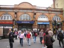
(Friday 7 August) Earls Court Tube Station.
Earl's Court tube station is a London Underground station in Earls Court. The station is located between Earls Court Road and Warwick Road (both A3220). It is on the boundary of Travelcard Zone 1 and Zone 2 and is in both zones. On the Piccadilly Line the station is between Barons Court and Gloucester Road. It is the major junction of the District Line, with West Brompton, Kensington (Olympia) and West Kensington to the west, High Street Kensington to the north and Gloucester Road to the east. (Quoted from the site of "Wikipedia") |
 |
lon2009-205
|
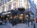
(Sunday 9 August) The Courtfield, 187 Earls Court Road, London, SW5 9AN, where I went every night before eating during my stay between August 7 - 10. |
 |
lon2009-116
|
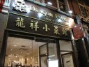
(Friday 7 August) Dragon Palace, 207 Earls Court Road London SW5 9AN, where I ate every night during my stay between August 7 - 10. |
 |
lon2009-117
|
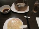
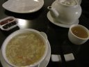
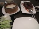
(Friday 7 August) Sweet crab egg soup, Dragon Palace, 207 Earls Court Road London SW5 9AN |
 |
lon2009-118
|
(Friday 7 August) Sweet crab egg soup and dumplings, Dragon Palace, 207 Earls Court Road London SW5 9AN |
 |
lon2009-119
|
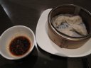
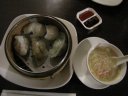
(Friday 7 August) Dumplings, Dragon Palace, 207 Earls Court Road London SW5 9AN |
 |
lon2009-120
|
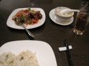
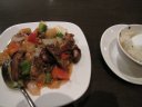
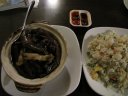
(Friday 7 August) Roast duck with mixed vegetables and fried rice, Dragon Palace, 207 Earls Court Road London SW5 9AN |
 |
lon2009-121
|
(Friday 7 August) Roast duck with mixed vegetables and fried rice, Dragon Palace, 207 Earls Court Road London SW5 9AN |
 |
lon2009-155
|
(Saturday 8 August) Crab egg soup and Chinese Jasmine tea, Dragon Palace, 207 Earls Court Road London SW5 9AN |
 |
lon2009-156
|
(Saturday 8 August) Dumplings and crab egg soup, Dragon Palace, 207 Earls Court Road London SW5 9AN |
 |
lon2009-158
|
(Saturday 8 August) Roast duck feet and special fried rice, 207 Earls Court Road London SW5 9AN |
 |
lon2009-206
|
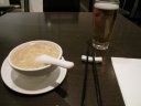
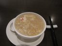
(Sunday 9 August) Crab egg soup, Dragon Palace, 207 Earls Court Road London SW5 9AN |
 |
lon2009-207
|
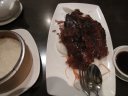
(Sunday 9 August) Half Peking [Roast] Duck, Dragon Palace, 207 Earls Court Road London SW5 9AN |
 |
lon2009-208
|
(Sunday 9 August) Half Peking [Roast] Duck, Dragon Palace, 207 Earls Court Road London SW5 9AN |
 |
lon2009-209
|
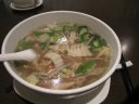
(Sunday 9 August) Vegetable Rice Soup Noodles, Dragon Palace, 207 Earls Court Road London SW5 9AN |
 |
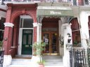
lon2009-002
|
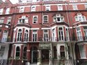
(Friday 7 August) Henley House Hotel, 30 Barkston Gardens, Earls Court, Kensington, London SW5 0EN, where I stayed between 7 - 10 August. |
 |
lon2009-004
|
(Friday 7 August) Henley House Hotel, 30 Barkston Gardens, Earls Court, Kensington, London SW5 0EN, where I stayed between 7 - 10 August. |
 |
lon2009-005
|
(Friday 7 August) Henley House Hotel, 30 Barkston Gardens, Earls Court, Kensington, London SW5 0EN, where I stayed between 7 - 10 August. |
 |
lon2009-007
|
(Friday 7 August) Henley House Hotel, 30 Barkston Gardens, Earls Court, Kensington, London SW5 0EN, where I stayed between 7 - 10 August. |
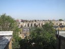 |
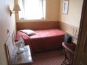
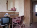
lon2009-122
|
(Saturday 8 August) A view from my room of Henley House Hotel. |
| |
|
|
| Jubilee Gardens |
|
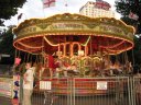
The Jubilee Gardens is a public park on the South Bank in London which was created in 1977 to mark the Silver Jubilee of Elizabeth II. The park is the site of a memorial to the casualties of the International Brigades of the Spanish Civil War, especially the British Battalion which took very heavy casualties. Its neighbours are the London Eye, the Shell Centre, County Hall and the River Thames. Plans for a complete redesign of the gardens were published in 2007. The site of the Jubilee Gardens was formerly used for the Dome of Discovery and the adjacent Skylon Tower during the Festival of Britain in 1951. (Referred to the site of "Wikipedia") |
 |
lon2009-125
|
(Saturday 8 August) The Carousel, the Jubilee Gardens, South Bank |
 |
lon2009-127
|
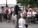
(Saturday 8 August) A performer pretending Charlie Chaplin, the Jubilee Gardens, South Bank |
 |
lon2009-128
|
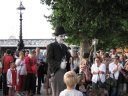
(Saturday 8 August) A performer pretending Charlie Chaplin, the Jubilee Gardens, South Bank |
| |
|
|
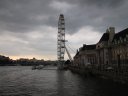
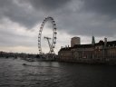
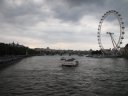
| The London Eye |
|
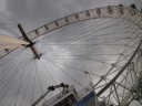
The Merlin Entertainments London Eye (known more simply as The London Eye, and also known as the Millennium Wheel), at a height of 135 meters (443 ft), is the largest Ferris wheel in Europe, and has become the most popular paid tourist attraction in the United Kingdom, visited by over three million people in one year. At the time it was erected, in 1999, it was the tallest Ferris wheel in the world, until it was surpassed by the Star of Nanchang (160 m) in May 2006, and then the Singapore Flyer (165 m) on 11 February 2008. However, it is still described by its operators as "the world's tallest cantilevered observation wheel" (as the entire structure is supported by an A-frame on one side only).
The London Eye is located at the western end of Jubilee Gardens, on the South Bank of the River Thames in London, England, between Westminster Bridge and Hungerford Bridge. The site is adjacent to that of the former Dome of Discovery, which was built for the Festival of Britain in 1951. (Referred to the site of "Wikipedia") |
 |
lon2009-130
|
(Saturday 8 August) The Merlin Entertainments London Eye, South Bank |
 |
lon2009-131
|
(Saturday 8 August) The Merlin Entertainments London Eye, South Bank |
 |
lon2009-132
|
(Saturday 8 August) The Merlin Entertainments London Eye, South Bank and River Thames |
 |
lon2009-133
|
(Saturday 8 August) The Merlin Entertainments London Eye, South Bank and River Thames |
;)
;)
;)
;)
;)
;)
;)
;)
;)
;)
;)
;)
;)
;)
;)
;)
;)
;)
;)
;)
;)
;)
;)
;)
;)
;)
;)