| IMAGE |
IMAGE NO.
|
DATA
|
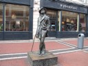
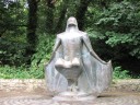
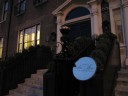
| Statue of James Joyce |
|
[U 06] Statue of James Joyce, North Earl Street, Dublin 1 |
 |
dub2013-010
|
Saturday 27 July) [U 06] Statue of James Joyce, North Earl Street |
| |
|
|
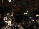
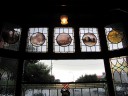
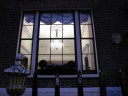
| [U 08.0732-1027] Davy Byrne's Pub |
|
[U 08.0732-1027] Davy Byrne's Pub, 21 Duke Street, Dublin 2 where Leopold Bloom eats lunch on a glass of Burgundy and Gorgonzola cheese sandwiches. |
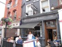 |
dub2013-014
|
(Saturday 27 July) [U 08.0732-1027] Davy Byrne's, 21 Duke Street |
 |
dub2013-016
|
(Saturday 27 July) [U 08.0732-1027] Davy Byrne's, 21 Duke Street |
| |
|
|
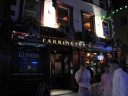
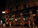
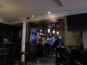
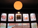
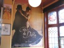
| Farrington's of Temple Bar |
|
Farrington's of Temple Bar, 28 Essex St E, Dublin 2. They also have five bedrooms for accommodation. It is named after a character of “Counterparts” of James Joyce's The Dubliners. |
�
 |
dub2013-032
|
(Saturday 27 July) Farrington's of Temple Bar, 28 Essex St E, Dublin 2 |
 |
dub2013-038
|
(Saturday 27 July) Farrington's of Temple Bar, 28 Essex St E, Dublin 2 |
�
 |
dub2013-039
|
(Saturday 27 July) Farrington's of Temple Bar, 28 Essex St E, Dublin 2 |
| |
|
|
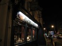
| Houricans Pub |
|
Patrick Hourican's Pub is located at 7 Lower Leeson Street, Dublin 2. It is very poplar among attendants of the UCD James Joyce Summer School. |
�
 |
dub2013-041
|
(Saturday 27 July) Hourican's Pub, 7 Lower Leeson Street, Dublin 2 |
 |
dub2013-042
|
(Saturday 27 July) Hourican's Pub, 7 Lower Leeson Street, Dublin 2 |
| |
|
|
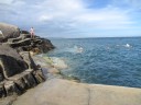
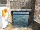
| [U 01] The Forty Foot |
|
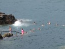
[U 01] The Forty Foot is a promontory on the southern tip of Dublin Bay at Sandycove, County Dublin, Ireland, from which people have been swimming in the Irish Sea all year round for some 250 years.
In former times it was kept solely as a gentlemen's bathing place and the gentlemen's swimming club was established to help conserve the area. Owing to its isolation and gender-specific nature it became a popular spot for nudists, but in the 1970s during the women's liberation movement, a group of female equal-rights activists plunged into the waters, now it is open to women and children as well. The gentlemen's swimming club still exists and is open to both genders, it expects voluntary contributions to the upkeep of the area. Many people believe that swimming in the extremely cold water is healthful.
There is no definite explanation for the origin of the name. It has been speculated that it may have been called the Forty Foot after the 42nd Highland Regiment of Foot (now known as the Black Watch), a regiment of the British Army, which is said to have been stationed here. Other suggestions forwarded include the depth of the water (actually less than 40 feet) and the width of the road leading to the bathing place.
James Joyce and Oliver St. John Gogarty once resided at the Martello tower together. It is now the James Joyce Tower and Museum. The opening section of Joyce's Ulysses is set here, with the characters Stephen Dedalus and Buck Mulligan being partly based on Joyce himself and Gogarty, respectively. Buck Mulligan described the sea as "The snotgreen sea. The scrotumtightening sea" (U 01.078).
The Forty Foot also featured in the novels At Swim-Two-Birds by Flann O'Brien (1939) and At Swim, Two Boys by Jamie O'Neill (2001). (Referred to the site of "Wikipedia")
|
 |
dub2013-045
|
(Sunday 28 July) A bird-view billboard of Sandycove Point, Dun Laoghaire |
 |
dub2013-047
|
(Sunday 28 July) 40 Foot, Sandycove Point, Dun Laoghaire |
|
 |
dub2013-054
|
(Sunday 28 July) 40 Foot, Sandycove Point, Dun Laoghaire |
 |
dub2013-056
|
(Sunday 28 July) 40 Foot, Sandycove Point, Dun Laoghaire |
 |
dub2013-058
|
(Sunday 28 July) 40 Foot, Sandycove Point, Dun Laoghaire |
 |
dub2013-059
|
(Sunday 28 July) 40 Foot, Sandycove Point, Dun Laoghaire |
 |
dub2013-060
|
(Sunday 28 July) 40 Foot, Sandycove Point, Dun Laoghaire |
 |
dub2013-062
|
(Sunday 28 July) 40 Foot, Sandycove Point, Dun Laoghaire |
| |
|
|
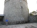
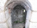
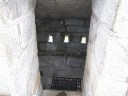
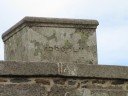
| [U 01] The James Joyce Tower and Museum |
|
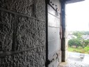
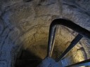
The James Joyce Tower and Museum is a Martello tower in Sandycove, Dun Laoghaire, where James Joyce spent six nights in 1904. The tower was leased from the British War Office by Joyce's university friend Oliver St. John Gogarty, with the purpose of "Hellenising" Ireland. Joyce left after an incident in which Gogarty fired a gun in his direction.
The opening scenes of Ulysses are set the morning after this incident. Gogarty is immortalised as "Stately, plump Buck Mulligan" (the opening words of the novel; [U 01. 001]).
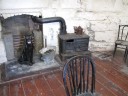
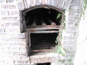
The tower now contains a museum dedicated to Joyce and displays some of his possessions and other ephemera associated with Ulysses (e.g. an empty pot of "Plumtree's Potted Meat"). The living space is set up to resemble its 1904 appearance (with a ceramic panther to represent one seen in a dream by a resident). It is a place of pilgrimage for Joyce enthusiasts, especially on Bloomsday.
The Tower became a museum through the efforts of the Dublin artist, John Ryan. Ryan also rescued the front door to 7 Eccles Street (now at the James Joyce Centre) from demolition and organised, with Brian O'Nolan, the first Bloomsday Celebration in 1954. (Referred to the site of "Wikipedia") |
�
 |
dub2013-071
|
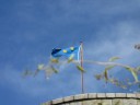
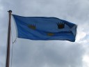
(Sunday 28 July) [U 12.1308-10] The Flag of "three crowns on a blue field" on top of The James Joyce Tower and Museum, Fortyfoot, Sandycove Point, Dun Laoghaire.
12.1300. --And with the help of the holy mother of God we will again, says the
12.1301. citizen, clapping his thigh. our harbours that are empty will be full again,
12.1302. Queenstown, Kinsale, Galway, Blacksod Bay, Ventry in the kingdom of
12.1303. Kerry, Killybegs, the third largest harbour in the wide world with a fleet of
12.1304. masts of the Galway Lynches and the Cavan O'Reillys and the
12.1305. O'Kennedys of Dublin when the earl of Desmond could make a treaty with
12.1306. the emperor Charles the Fifth himself. And will again, says he, when the
12.1307. first Irish battleship is seen breasting the waves with our own flag to the
12.1308. fore, none of your Henry Tudor's harps, no, the oldest flag afloat, the flag
12.1309. of the province of Desmond and Thomond, three crowns on a blue field, the
12.1310. three sons of Milesius.
See Don Gifford & Robert J. Seidman, Notes for James Joyce's "Ulysses" (1989), p. 356:
12-1308-10 (328.10-12). the oldest flag afloat ... sons of Milesius - The Province of Munster in southwestern Ireland was divided in ancient Ireland into Desmond (South Munster) and Thomond (North Munster). The last of the quasi-legendary invaders of Ireland were the Milesians, led by the three sons of Mileadh of Spain (Eber, Heremon, and Ith or Iar, the latter sometimes characterized as a brother of Mileadh rather than son). Legend has it that the Milesian flag had "three crowns on a blue field" and that it was "the oldest flag afloat" in Ireland; legend also regards the Milesians as the "Ancestors" of the royal clans of Ireland.
Three Crowns (Swedish: Tre Kronor) is a national emblem of Sweden, present in the Coat of Arms of the Realm of Sweden, and composed by three yellow or gilded coronets ordered two above and one below, placed on a blue background. The emblem is often used as a symbol of authority by the Swedish government and by Swedish embassies around the world, but also appears in other less formal contexts, such as the Swedish national men's ice hockey team, who wear the symbol on their sweaters and hence are called "Three Crowns" (usually blue crowns on yellow shirt), and atop the Stockholm City Hall built 1911-1923. The Three Crowns are also used as the roundel on military aircraft of the Swedish Air Force and as a sign on Swedish military equipment in general, and also on the uniforms and vehicles of the Swedish Police Service.
Because of their common Scandinavian origin, the Three Crowns are also featured in the royal coat of arms of Denmark where they might be referred to as the "union mark."
The origin of the Three Crowns symbol has been much debated throughout history and various more or less well-founded theories have attempted to shed some light on the matter. One of several, earlier, traditional explanations have suggested Albrekt of Mecklenburg (1338-1412), who ruled Sweden 1364-1389, brought the symbol from Germany as a sign of his reign of Sweden, Finland and Mecklenburg. Apart from the fact that Finland was not regarded as a country in its own right at the time, this theory has, however, been refuted by later research, namely, the announcement in 1982 of the discovery of a frieze in Avignon in southern France, estimated to date back to 1336. The frieze was painted for an international congress led by the Pope and contains the symbols of all participant countries, including Sweden. This discovery suggests the symbol was introduced no later than by Albert's predecessor Magnus Eriksson (1316-1377).
Use of the three crowns as a heraldic symbol of Sweden has been attested, in the Nordisk Familjebok, to the late 13th century, the three crowns first ringing the shield of Magnus Ladulas (1240-1290) and later appearing on the coins of Magnus Eriksson (1316-1374).
In British and Irish armoury
Practically identical to the three crowns of Sweden, is that of the flag and crest of the Province of Munster, a region in the south west of Ireland. Like the Swedish model, it comprises two crowns above and one below. These represent the three great duchies of the province, Desmond, Ormond and Thomond. The design was used as the flag of the Lordship of Ireland between 1171-1541 following the Norman invasion of Ireland until being replaced by the flag of the Kingdom of Ireland. A similar three crowns design is the crest of the city of Kingston-upon-Hull, a large port in Yorkshire, England. This design sees the three crowns stacked vertically and relates back to the Royal charter of 1299. The emblem is used by the city council and the city's two rugby league teams.
In the literature, the coat of arms of King Arthur of Logres is also azure with three crowns or. Indeed, Britain included three realms, Logres, Cambria and Alba. The University of Oxford uses as its emblem the three gold crowns on blue accompanied by an open book. The origin of the three crowns is not exactly known but may refer to the arms of Thomas Cranley, Warden of New College between 1389 and 1396.
The flag of St Edmund consists of three gold crowns on a field of blue (Azure, three crowns Or), and features as the three crowns of East Anglia, on the baptismal font (c.1400) in Saxmundham's parish church in Suffolk, UK. The first corporate coat of arms was granted in 1439 to the Drapers' Company in London with three triple crowns. Three crowns also form the logo of Coutts & Co, the London based private bankers, but in this case the design comprises one crown at the top, with two below. (Referred to the site of "Wikipedia")
|
 |
dub2013-073
|
(Sunday 28 July) [U 12.1308-10] The Flag of "three crowns on a blue field" on top of The James Joyce Tower and Museum, Fortyfoot, Sandycove Point, Dun Laoghaire. |
 |
dub2013-076
|
(Sunday 28 July) [U 01] The James Joyce Tower and Museum, Fortyfoot, Sandycove Point, Dun Laoghaire |
 |
dub2013-078
|
(Sunday 28 July) [U 01] The James Joyce Tower and Museum, Fortyfoot, Sandycove Point, Dun Laoghaire |
 |
dub2013-080
|
(Sunday 28 July) [U 01] The James Joyce Tower and Museum, Fortyfoot, Sandycove Point, Dun Laoghaire |
 |
dub2013-086
|
(Sunday 28 July) [U 01] The James Joyce Tower and Museum, Fortyfoot, Sandycove Point, Dun Laoghaire |
 |
dub2013-087
|
(Sunday 28 July) [U 01] The James Joyce Tower and Museum, Fortyfoot, Sandycove Point, Dun Laoghaire |
 |
dub2013-088
|
(Sunday 28 July) [U 01] The James Joyce Tower and Museum, Fortyfoot, Sandycove Point, Dun Laoghaire |
 |
dub2013-089
|
(Sunday 28 July) [U 01] The James Joyce Tower and Museum, Fortyfoot, Sandycove Point, Dun Laoghaire |
 |
dub2013-090
|
(Sunday 28 July) [U 01] The James Joyce Tower and Museum, Fortyfoot, Sandycove Point, Dun Laoghaire |
 |
dub2013-093
|
(Sunday 28 July) [U 01] The James Joyce Tower and Museum, Fortyfoot, Sandycove Point, Dun Laoghaire: me on the roof |
 |
dub2013-094
|
(Sunday 28 July) [U 01] The James Joyce Tower and Museum, Fortyfoot, Sandycove Point, Dun Laoghaire: Paul O'Hanrahan on the roof |
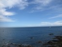 |
dub2013-095
|
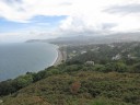
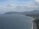
(Sunday 28 July) [U 01] A view from the rooftop of The James Joyce Tower and Museum, Fortyfoot, Sandycove Point, Dun Laoghaire |
 |
dub2013-096
|
(Sunday 28 July) [U 01] A view from the rooftop of The James Joyce Tower and Museum, Fortyfoot, Sandycove Point, Dun Laoghaire |
 |
dub2013-098
|
(Sunday 28 July) [U 01] A view from the rooftop of The James Joyce Tower and Museum, Fortyfoot, Sandycove Point, Dun Laoghaire |
 |
dub2013-100
|
(Sunday 28 July) [U 01] A view from the rooftop of The James Joyce Tower and Museum, Fortyfoot, Sandycove Point, Dun Laoghaire |
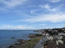
 |
dub2013-103
|
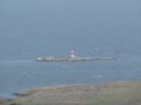
(Sunday 28 July) [U 01] A view from the rooftop of The James Joyce Tower and Museum, Fortyfoot, Sandycove Point, Dun Laoghaire: The Muglins*
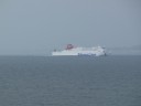
*The Rocks to the east of the Island are known as "The Muglins" and are a different group or chain. These form a danger to shipping and have been fitted with a distinctive beacon. |
 |
dub2013-106
|
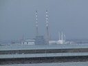
(Sunday 28 July) [U 01] A view from the rooftop of The James Joyce Tower and Museum, Fortyfoot, Sandycove Point, Dun Laoghaire: A ferry to Holyhead, UK |
 |
dub2013-108
|
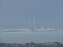
(Sunday 28 July) [U 01] A view from the rooftop of The James Joyce Tower and Museum, Fortyfoot, Sandycove Point, Dun Laoghaire: "The Pigeon House" (Poolbeg Generating Station) |
�
| |
|
|
| [U 02] Clifton School |
|
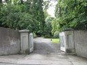
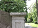
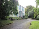
[U 02] Clifton School ("Mr. Deasy's school" on Clifton Avenue in Dalkey) where Mr. Deasy is schoolmaster. Dalkey is a seaside suburb of Dublin, some 13km (8 miles) south-east of the city center. Known for its medieval streetscapes and castle, it was a major port for Dublin in the Middle Ages. Joyce taught history in Clifton School for one term (from March to June) in 1904: It was Joyce's first and only job in Ireland. The school is today a private residence called Summerfield Lodge owned by a professional musician. (Referred to "Joyce Images/Nestor" by Aida Yared) |
�
 |
dub2013-110
|
(Sunday 28 July) [U 02] Clifton School (now Summerfield Lodge), Dalkey, Co. Dublin
|
�
 |
dub2013-112
|
(Sunday 28 July) [U 02] Clifton School (now Summerfield Lodge), Dalkey, Co. Dublin |
�
 |
dub2013-114
|
(Sunday 28 July) [U 02] Clifton School (now Summerfield Lodge), Dalkey, Co. Dublin |
�
 |
dub2013-115
|
(Sunday 28 July) [U 02] Clifton School (now Summerfield Lodge), Dalkey, Co. Dublin |
 |
dub2013-117
|
(Sunday 28 July) [U 02] Clifton School (now Summerfield Lodge), Dalkey, Co. Dublin |
�
 |
dub2013-123
|
(Sunday 28 July) [U 02] Clifton School (now Summerfield Lodge), Dalkey, Co. Dublin |
�
 |
dub2013-125
|
(Sunday 28 July) [U 02] Clifton School (now Summerfield Lodge), Dalkey, Co. Dublin |
| |
|
|
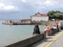
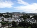
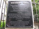
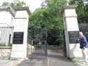
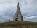
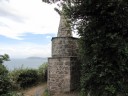
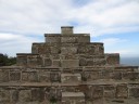
| Victoria Hill |
|
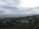
Victoria Hill Park (Killiney Hill Park). The decision was made in May of 1887 to open the ‘Obelisk Hill of Killiney’ as a public park due to ‘a strong desire having been expressed by many citizens of Dublin to adopt the opening of public parks and pleasure-grounds as a form of memorial to commemorate the Queen’s Jubilee.’ The park was to be obtained from its owner Mr. Robert Warren upon ‘very favourable terms for conversion into a free pleasure- ground for the people Dublin and its vicinity.’ It would appear that the park had already been accessible in the past to the public - though possibly on a limited basis (see figs 2 and 3). In 1887 one member of the Jubilee Memorials Association commented that Mr. Warren was very liberal in providing access to the hill and it was feared that if they did not avail of his offer of sale then the new owner would make it inaccessible. (UCD archaeology) |
�
 |
dub2013-126
|
(Sunday 28 July) Killiney Hill Park (formerly known as Victoria Hill Park), Killiney, Co Dublin |
�
 |
dub2013-129
|
(Sunday 28 July) Killiney Hill Park (formerly known as Victoria Hill Park), Killiney, Co Dublin |
�
 |
dub2013-135
|
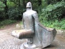
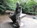
(Sunday 28 July) Killiney Hill Park (formerly known as Victoria Hill Park), Killiney, Co Dublin: "Thus Daedalus Flew" by Niall O'Neill (1988) |
 |
dub2013-136
|
(Sunday 28 July) Killiney Hill Park (formerly known as Victoria Hill Park), Killiney, Co Dublin: "Thus Daedalus Flew" by Niall O'Neill (1988) |
�
 |
dub2013-138
|
(Sunday 28 July) Killiney Hill Park (formerly known as Victoria Hill Park), Killiney, Co Dublin: "Thus Daedalus Flew" by Niall O'Neill (1988) |
 |
dub2013-151
|
(Sunday 28 July) Killiney Hill Park (formerly known as Victoria Hill Park), Killiney, Co Dublin: The Obelisk |
 |
dub2013-154
|
(Sunday 28 July) Killiney Hill Park (formerly known as Victoria Hill Park), Killiney, Co Dublin: The Small Obelisk |
�
 |
dub2013-155
|
(Sunday 28 July) Killiney Hill Park (formerly known as Victoria Hill Park), Killiney, Co Dublin: The Pyramid |
 |
dub2013-156
|
(Sunday 28 July) Killiney Hill Park (formerly known as Victoria Hill Park), Killiney, Co Dublin: The top of The Pyramid |
 |
dub2013-157
|
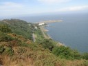
(Sunday 28 July) Killiney Hill Park (formerly known as Victoria Hill Park), Killiney, Co Dublin: the east view |
 |
dub2013-160
|
(Sunday 28 July) Killiney Hill Park (formerly known as Victoria Hill Park), Killiney, Co Dublin: the east view |
 |
dub2013-164
|
(Sunday 28 July) Killiney Hill Park (formerly known as Victoria Hill Park), Killiney, Co Dublin: the south view |
 |
dub2013-166
|
(Sunday 28 July) Killiney Hill Park (formerly known as Victoria Hill Park), Killiney, Co Dublin: A view of The Muglins*
*The Rocks to the east of the Island are known as "The Muglins" and are a different group or chain. These form a danger to shipping and have been fitted with a distinctive beacon. |
 |
dub2013-177
|
(Sunday 28 July) Killiney Hill Park (formerly known as Victoria Hill Park), Killiney, Co Dublin: A view of "The Pigeon House" (Poolbeg Generating Station) |
| |
|
|
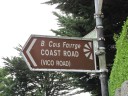
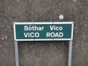
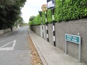
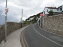
| [U 02.025 & FW 246.25&452.21] Vico Road |
|
[U 02.025 & FW 246.25&452.21] Vico Road, , Dalkey, Co. Dublin |
�
 |
dub2013-169
|
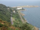
(Sunday 28 July) [U 02.025 & FW 246.25&452.21] A view of Vico Road from Killiney Hill Park (formerly known as Victoria Hill Park), Dalkey, Co. Dublin |
 |
dub2013-173
|
(Sunday 28 July) [U 02.025 & FW 246.25&452.21] A view of Vico Road from Killiney Hill Park (formerly known as Victoria Hill Park), Dalkey, Co. Dublin |
 |
dub2013-183
|
(Sunday 28 July) [U 02.025 & FW 246.25&452.21] Vico Road, Dalkey, Co. Dublin |
 |
dub2013-185
|
(Sunday 28 July) [U 02.025 & FW 246.25&452.21] Vico Road, Dalkey, Co. Dublin |
 |
dub2013-189
|
(Sunday 28 July) [U 02.025 & FW 246.25&452.21] Vico Road, Dalkey, Co. Dublin |
 |
dub2013-191
|
(Sunday 28 July) [U 02.025 & FW 246.25&452.21] Vico Road, Dalkey, Co. Dublin |
| |
|
|
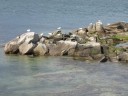
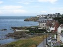
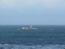
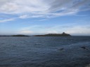
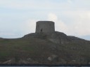
| Dalkey Island |
|
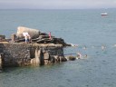
Dalkey Island (Irish: Deilginis meaning "thorny island") is an uninhabited island about 16 km (10 mi) south of Dublin, near the village of Dalkey, 3 km (2 mi) south of Dun Laoghaire harbour. Its name is a meld of the Irish "deilg" ("thorn") and the Old Norse "oy" ("island").
Although the island is currently uninhabited, the remains of houses, a church and the Martello Tower still exist. Located less than 300 metres off the mainland, the island comprises 9 hectares (22 acres). From Bulloch Harbour, it is possible to visit the island.
Dalkey Island, only 5 minutes by boat from Coliemore and Bulloch Harbours, is an important site of ancient and historic remains. Artefacts from the island, now housed in the National Museum in Dublin, provide evidence that the island's original occupants were from the Mesolithic, or Middle Stone Age. Humans continued to use the site through the Iron Age and Early Christian period.
There is evidence it was inhabited in the 4th millennium BC (6,000 years ago) and was also used as a Viking base. There are ruins of another church, dating from the 7th century, named after St Begnet. This was altered on the east side when builders used it as living quarters while building the nearby Martello tower and gun battery in 1804. An older wooden church was probably here before the present stone one was built.
A promontory fort was located at the northern end of the island, its presence still visible today in the form of a ditch. A herd of goats, originally put there in the early 19th century, remains there today but they are replacements of the original goats which were removed.
The ruined stone church was built in the 9th/10th century and was probably abandoned when the Vikings used the island as a base to form part of the busiest port in the country at that time. In the early 19th century the British Admiralty erected the Martello Tower, one of eight dotted along the Dun Laoghaire coastline, as an early warning defensive device against the one time threat of invasion during the Napoleonic Wars.
The island is also an ideal spot for fishing, with Pollock, Coalfish, Wrasse and Mackerel being caught. The channel between the island and the mainland is very deep and was once considered as a location for an oil terminal. However, the local area is very residential, and it was decided that the terminal should go elsewhere. The waters around Dalkey Island are much used for sailing, angling and diving. Rocks known as Maiden or Carraig Rock, Clare Rock and Lamb Island all to the northwest form part of the ridge of the Island. Parts of these rocks are only visible at low tide. The southern end of the Island is a favorite with kayakers especially on the flooding tide. There can be a substantial overfall here and in a southeast wind can be extremely challenging for the kayaker. When kayaking around the Island on a flood tide it is easier to go in an anti clockwise direction. Dalkey Island is home to a colony of seals which has greatly expanded in recent years. A herd of wild goats live on the island also. Birdwatch Ireland has established a colony of Roseate Terns on Maiden Rock just north of the Island. More recently a pod of three bottlenose dolphins has begun frequenting the waters around Dalkey Island. (Referred to the site of "Wikipedia")
|
�
 |
dub2013-192
|
(Sunday 28 July) Dalkey Island, Dalkey, Co. Dublin |
 |
dub2013-193
|
(Sunday 28 July) The Martello tower of Dalkey Island, Dalkey, Co. Dublin |
| |
|
|
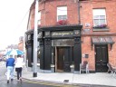
| Finnegan's of Dalkey |
|
Finnegan's of Dalkey is located at 2 Sorrento Road, Dalkey, Co. Dublin.
On Tuesday 18 June 2013 Bono (U2) and his wife Ali Hewson invited the First Lady of the United States Michelle Obama and her daughters Malia and Sasha here for lunch. The three came at 1.20 p.m. after visiting Glendalough. All three requested fish and chips while Mrs Obama chose the lobster starter and left just before 3 p.m., waving to the crowd as she went." Bono said he and the Obamas had discussed everything and nothing over lunch and had talked about their families." (Source: The Irish Times on the web first published: Tue, Jun 18, 2013, 06:31).
|
�
 |
dub2013-198
|
(Sunday 28 July) Finnegan's of Dalkey, 2 Sorrento Road, Dalkey, Co. Dublin |
 |
dub2013-199
|
(Sunday 28 July) Finnegan's of Dalkey, 2 Sorrento Road, Dalkey, Co. Dublin |
 |
dub2013-200
|
(Sunday 28 July) Finnegan's of Dalkey, 2 Sorrento Road, Dalkey, Co. Dublin |
 |
dub2013-201
|
(Sunday 28 July) Finnegan's of Dalkey, 2 Sorrento Road, Dalkey, Co. Dublin: me |
 |
dub2013-202
|
(Sunday 28 July) Finnegan's of Dalkey, 2 Sorrento Road, Dalkey, Co. Dublin: Paul O'Hanrahan |
| |
|
|
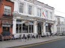
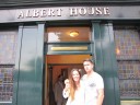
| Fitzgeralds (Albert House) |
|
Fitzgeralds (Albert House) is a Joycean pub located at 11 Sandycove Road, Dun Laoghaire, Co. Dublin. |
�
 |
dub2013-207
|
(Sunday 28 July) Fitzgeralds (Albert House), 11 Sandycove Road, Dun Laoghaire, Co. Dublin |
 |
dub2013-208
|
(Sunday 28 July) Fitzgeralds (Albert House), 11 Sandycove Road, Dun Laoghaire, Co. Dublin |
 |
dub2013-209
|
(Sunday 28 July) Fitzgeralds (Albert House), 11 Sandycove Road, Dun Laoghaire, Co. Dublin |
 |
dub2013-216
|
(Sunday 28 July) Fitzgeralds (Albert House), 11 Sandycove Road, Dun Laoghaire, Co. Dublin |
 |
dub2013-219
|
(Sunday 28 July) Fitzgeralds (Albert House), 11 Sandycove Road, Dun Laoghaire, Co. Dublin |
 |
dub2013-221
|
(Sunday 28 July) Fitzgeralds (Albert House), 11 Sandycove Road, Dun Laoghaire, Co. Dublin |
| |
|
|
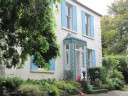
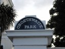
| John Millington Synge House |
|
In 1890 Synge's mother moved from Rathgar to 31Crosthwaite Park West, Dun Laoghaire. It was during the time at Crosthwaite Park that Synge’s writing developed and he made his tips to the Aran Islands. Synge’s mother later moved to Glendalough House on Adelaide Road where she reserved a large room for him at the back where he could finish writing The Playboy of the Western World. (Quoted from "Mountains to Sea"/J.M. Synge)
He lived here from 1890 to 1906. |
�
 |
dub2013-222
|
(Sunday 28 July) Crosthwaite Park, Dun Laoghaire, Co Dublin |
 |
dub2013-225
|
(Sunday 28 July) John Millington Synge House (1890-1906) at 31Crosthwaite Park West, Dun Laoghaire, Co Dublin |
 |
dub2013-227
|
(Sunday 28 July) John Millington Synge House (1890-1906) at 31Crosthwaite Park West, Dun Laoghaire, Co Dublin |
 |
dub2013-229
|
(Sunday 28 July) John Millington Synge House (1890-1906) at 31Crosthwaite Park West, Dun Laoghaire, Co Dublin |
| |
|
|
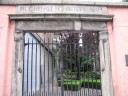
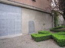
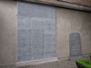
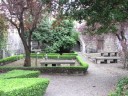
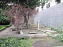
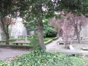
| [U 05.465, etc. & FW] The Huguenot Cemetery |
|
The Huguenot Cemetery (Irish: Reilig na nUgoineach) is a small cemetery dating from 1693 located near St. Stephen's Green, Dublin, Ireland, beside the Shelbourne Hotel. Although often described as being on the green, it is actually on the north side of Merrion Row, a small street linking St. Stephen's Green with Upper Merrion Street and Ely Place.
Those buried there are descendants of Huguenots who fled persecution in France following the revocation of the Edict of Nantes which had guaranteed religious freedom. They were encouraged to come to Ireland by James Butler, 1st Duke of Ormonde, who had spent twelve years in exile in France, after the Irish and Royalist forces were defeated by those of Oliver Cromwell. Ormonde's return to Ireland as Viceroy in 1662 coincided with the consolidation of power by Louis XIV, which put extra pressure on the Huguenots in France. Ormonde had come into contact with Huguenots in Paris and Normandy, and hoped that their skills and capital could help stimulate the Irish economy and introduce new industries.
The Huguenots quickly established a thriving community in Dublin and elsewhere in Ireland based on their skills in textiles, watchmaking and finance. Within a short time they had become an integral part of the commercial and civic life of Dublin. Huguenot families in Ireland included the naturalized names of Busse, Des Voeux, Chaigneau, D'Olier, Gardie, Le Fanu, L'Estrange, Maturin, Saurin, Lefroy, Le Nauze, Perrin, Cromelin, Borough (derived from Boroher) and La Touche.
The cemetery is not open to visitors, though it is visible through the railings and a list of 239 surnames of those buried is inscribed on the wall plaque to the left. These include Becquett (relatives of Samuel Beckett) and Dubedad. Jean-Paul Pittion, one of the editors of The Hugenots in Ireland, an Anatomy of an Emigration, was instrumental in having the cemetery restored, which by the late 1970s had fallen into a serious state of disrepair. (Referred to the site of "Wikipedia")
|
 |
dub2013-246
|
(Tuesday 30 July) [U 05.465, etc. & FW] The Huguenot Cemetery, 12-13 Merrion Row, Dublin |
 |
dub2013-249
|
(Tuesday 30 July) [U 05.465, etc. & FW] The Huguenot Cemetery, 12-13 Merrion Row, Dublin |
 |
dub2013-250
|
(Tuesday 30 July) [U 05.465, etc. & FW] The Huguenot Cemetery, 12-13 Merrion Row, Dublin |
 |
dub2013-252
|
(Tuesday 30 July) [U 05.465, etc. & FW] The Huguenot Cemetery, 12-13 Merrion Row, Dublin |
 |
dub2013-253
|
(Tuesday 30 July) [U 05.465, etc. & FW] The Huguenot Cemetery, 12-13 Merrion Row, Dublin |
 |
dub2013-255
|
(Tuesday 30 July) [U 05.465, etc. & FW] The Huguenot Cemetery, 12-13 Merrion Row, Dublin |
 |
dub2013-258
|
(Tuesday 30 July) [U 05.465, etc. & FW] The Huguenot Cemetery, 12-13 Merrion Row, Dublin |
 |
dub2013-260
|
(Tuesday 30 July) [U 05.465, etc. & FW] The Huguenot Cemetery, 12-13 Merrion Row, Dublin |
| |
|
|
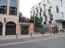
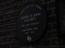
| Oliver St. John Gogarty Rooms |
|
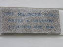
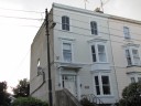
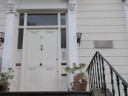
Oliver St. John Gogarty (1878 - 1957), poet and surgeon had rooms here (27 St Stephen's Green, Dublin 2) in the Georgian townhouse between 1915 - 1917. |
 |
dub2013-263
|
(Tuesday 30 July) Oliver St. John Gogarty's rooms 1915-1917), 27 St Stephen's Green, Dublin 2 |
 |
dub2013-265
|
(Tuesday 30 July) Oliver St. John Gogarty's rooms 1915-1917), 27 St Stephen's Green, Dublin 2 |
 |
dub2013-268
|
(Tuesday 30 July) Oliver St. John Gogarty's rooms 1915-1917), 27 St Stephen's Green, Dublin 2 |
;)
;)
;)
;)
;)
;)
;)
;)
;)
;)
;)
;)
;)
;)
;)
;)
;)
;)
;)
;)
;)
;)
;)
;)
;)
;)
;)
;)
;)
;)
;)
;)
;)
;)
;)
;)
;)
;)
;)
;)
;)
;)
;)
;)
;)
;)
;)
;)
;)
;)
;)
;)
;)
;)
;)
;)
;)
;)
;)
;)
;)
;)
;)
;)
;)
;)
;)
;)
;)
;)
;)
;)
;)
;)
;)
;)
;)
;)
;)
;)
;)
;)
;)
;)
;)
;)
;)
;)
;)
;)