 Aterui Courtesy of Wel Sunpia Iwate Kanegasaki |
Aterui (阿弖流為) the
"Tamo-no-kimi" (大墓公; Lord of Tamo*)
(?-802) was the greatest chief of "Emishi" (蝦夷) people of Isawa (胆沢), the ancient
Tohoku
District, in
the northern part of the main island of
Japan.
He lived in Isawa (now Mizusawa Ward, Oshu City, southern Iwate) and fought with
Tamuramaro Sakanoue (坂上 田村麻呂, 758-811), the legendary Shogun leading the
powerful
army of "Yamato Chotei" (大和朝廷), the ancient Japanese Government based in Nara
and later in Kyoto at the turn of the
ninth century (789-802). *"Tamo" is probably the place name which is known as "Tamo-yama," Hada (羽田 田茂山), east of Mizusawa. |
|
| The Historical Background |
|
By that time the northern Japan
known as "Kita-Tohoku" District
was not included in "Japan: it was "Emishi" or "Ezo" (both use the same
Chinese characters which literally mean "barbarian") Country free from
the Japanese control. So Aterui and his tribes were not
"Yamato" or
the ancient "Japanese."
Or in the strict sense, there were not regarded as the
"Japanese
citizens" by the ancient Japanese government. At that time,
the
government tried to territorialize all over the Japanese Isles (not yet
Hokkaido).
The government under the reign of the ambitious Emperor Kanmu (桓武天皇; r.781-806) sent the army to the Tohoku District many times. But Aterui's platoon (about 500 soldiers) succeeded to beat Shogun Kosami Kino (紀 古佐美)'s troops of more than 50,000 Yamato soldiers in 789, which greatly surprised the Yamato Chotei. They felt confounded dread of Aterui. Then Emperor Kanmu anointed Tamuramaro Sakanoue as the vice Shogun in 794 and he was promoted Shogun in 801 to fight with Aterui and his Chief General Staff More the "Iwagu-no-kimi" (磐具公母禮; lit."Lord of Rock Armor"?: probably Lord of Motai, Maesawa [前沢区母体]). The details of their battle was unknown but "Emishi" was defeated in the battle as the fact that the Yamato Chotei's new military base (government office) "Isawa-jo Castle" began to construct in 802. Hoping peace for the "Emishi" people, Aterui and More threw down their arms on April 15, 802 and were captured by Tamuramaro Sakanoue who safeguarded them to the Chotei in Kyoto. As the historical documents tell, Tamuramaro Sakanoue tried to persuade his superiors and Emperor Kanmu to save Aterui and More's lives to work for ruling the former "Emishi" Country, but they never agreed with him: Aterui and More were sent to Sugiyama (椙山/杜山/植山), Kawachi-no-kuni (河内国; presumably now Hirakata City, Osaka) to be beheaded on August 13, 802 (in the Chinese Lunar Calendar; September 18, 802 in the current Solar Calendar). |
|
However,
the tragedy of Aterui had just begun with his death: The Japanese
people in later generations
worshipped Tamuramaro Sakanoue as a guardian saint of Japan while they
mistakenly regarded Aterui
as a demon-like figure with an evil spirit and injured his human
dignity in numerous folk tales. It was not so long ago that
Japanese
historians acknowledged that the descriptions of Aterui as "Acro-o" (more precisely pronounced "Akuro-o" (悪路王); lit.
"Lord of the Bad Road") and
"Aka-gashira" ("Red Head") in many Japanese folk tales. He was long believed to be a devil-like figure while his rival Tamuramaro Sakanoue left many heroic stories over East and Northern Japan. Even in Mizusawa, most people like Sakanoue. In my childhood, I was so confused between Aterui and Sakanoue. Especially I did not understand why Aterui was called as "Acro-o" (悪路王; Lord of the Bad Road) and "Aka-gashira" (赤頭; "Red Head") in the legends of Sakanoue from Fukui to Northern Japan. It was not so long ago that historians and the local people came to think that the descriptions of Aterui as "Acro-o" were not based on his real life: Most of his legends was forged by the who blindly believed in Sakanoue Tamuramaro as the great hero after years without knowing the historical truth. |
| IMAGE |
|
|
| Tsunozuka-kofun |
|
The "Tsunozuka-kofun" (角塚古墳; the Tsunozuka Tumulus, Tsukada, Natsuta, Isawa Ward, Oshu City; along the national route 397) is assumed to have been constructed for a head of a powerful family in the fifth century. Its style is called "Zenpo-koen-fun" (前方後円墳; the ancient burial mound, square at the head and rounded at the foot). This is a historic site specially designated by the national government because it is the northernmost "Zenpo-koen-fun" of the Japan proper. County Isawa or Oshu City is known for the area having the largest number of historic sites in the "Kofun" Period (the period of ancient burial mounds between the late 3-7 centuries).
A legend tells: Long long ago, the wife of "Takayama-Kamon-chojya" (高山掃部長者; Takayama-Kamon the Rich Man) somehow metamorphosed into "Daijya" (大蛇; the huge serpent or dragon) who was cruel to the local peasantry for a long time and they were so helpless against the monster. Finally "Sayo-hime" (小夜姫; Princess Sayo) succeeded to slay the Daijya with chanting the Buddhist sutra. She buried the monster's horn in this place later called "Tsuno-zuka" (角塚) which literally means the "burial mound for the horn." This site is not directly related to Aterui, but it clealy shows that this area has been very rich since the ancient times. |
;) |
|
(Saturday 19 August) "Tsunozuka-kofun" (the Tsunozuka Tumulus), Tsukada, Natsuta, Isawa Ward, Oshu City; along the national route 397 |
;) |
|
(Saturday 19 August) "Tsunozuka-kofun" (the Tsunozuka Tumulus), Tsukada, Natsuta, Isawa Ward, Oshu City; along the national route 397 |
;) |
|
(Saturday 19 August) "Tsunozuka-kofun" (the Tsunozuka Tumulus), Tsukada, Natsuta, Isawa Ward, Oshu City; along the national route 397 |
;) |
|
(Saturday 19 August) "Tsunozuka-kofun" (the Tsunozuka Tumulus), Tsukada, Natsuta, Isawa Ward, Oshu City; along the national route 397 |
;) |
|
(Saturday 19 August) "Tsunozuka-kofun" (the Tsunozuka Tumulus), Tsukada, Natsuta, Isawa Ward, Oshu City; along the national route 397 |
|
|
||
| Shikinai-sha-Iwatei-jinjya |
|
Originally a local "Emishi" shrine for worshipping the God of Water stood in this place located near the eastern edge of Fuji Bridge across the Kitakami River.
Shikinai-sha-Iwatei-jinjya (式内社石手堰神社) was recorded as "Mutsu-chinjyu-fu sho-6-i-jo Iwatei-shin" in June, 4th year of Jogan era, the "San-dai Jitsuroku" (lit. the Authentic Record of Three Reigns [about 30 years of Emperors Seiwa, Yozei and Koko's reigns, 50 vols.] in 862 as , after the Yamato Chotei's conquest. This shrine is also recorded in "Shinmyocho" (lit. the Book of Deity) of Engi-shiki (the ancient Japanese capitulary published in 927; "Engi" (901-923) is one era of Emperor Daigo (885-930: r.897-930). It seems that it was the ancient Japanese government's strategy ruling the Tohoku District that they built a Japanese shrine or a Buddhist temple in the old Emishi's sacred place or castle remains. One reason is to show their new authority for the local people; another reason is for fear the direct influence of evil spirits. Now they enshrine "Ame-no-Oshihomimi-no-Mikoto," a son of "Amaterasu 0 Mikami" (The Japanese sun god), but the original god is unknown. |
;) |
|
(Tuesday 29 March) Shikinai-sha-Iwatei-jinjya Shrine (式内社石手堰神社), Kojima, Kuroishi-cho, Mizusawa. |
;) |
|
(Tuesday 29 March) Shikinai-sha-Iwatei-jinjya Shrine (式内社石手堰神社), Kojima, Kuroishi-cho, Mizusawa. |
;) |
|
(Tuesday 29 March) Shikinai-sha-Iwatei-jinjya Shrine (式内社石手堰神社), Kojima, Kuroishi-cho, Mizusawa. |
;) |
|
(Tuesday 29 March) A small shrine of Shikinai-sha-Iwatei-jinjya Shrine (式内社石手堰神社), Kojima, Kuroishi-cho, Mizusawa. |
;) |
|
(Tuesday 29 March) The Main Hall ("Iwa-mori"; lit. "Rock Shrine"), standing on the top of Iwamori, Shikinai-sha-Iwatei-jinjya Shrine (式内社石手堰神社), Kojima, Kuroishi-cho, Mizusawa. |
;) |
|
(Tuesday 29 March) Main Hall ("Iwa-mori"; lit. "Rock Shrine"), standing on the top of Iwamori, Shikinai-sha-Iwatei-jinjya Shrine (式内社石手堰神社), Kojima, Kuroishi-cho, Mizusawa. |
;) |
|
(Tuesday 29 March) Interior of the main hall ("Iwa-mori"; lit. "Rock Shrine"), standing on the top of Iwamori, Shikinai-sha-Iwatei-jinjya Shrine (式内社石手堰神社), Kojima, Kuroishi-cho, Mizusawa. |
;) |
|
(Tuesday 29 March) A western view (towards the Kitakami River) from the shrine hill. Shikinai-Iwatei-jinjya Shrine, Kojima, Kuroishi-cho, Mizusawa. The western marsh is the vestige of the old stream of the Kitakami River along the Kitakami Mountains. |
|
|
||
| Aterui's Birthplace |
|
"Aterui-no-Sato" (阿弖流為の郷; Aterui Square); the legendary birthplace of Aterui, Atoroi, Mizusawa, Oshu City (奥州市水沢区跡呂井). This small park, located in Tokiwa Area in East Mizuzawa, was established in memory of Aterui in 1994. As the information board says, the Emishi people did not have a charactery to express their ideas. So they did not leave any record by themselves. This monument, shaped a flamed earthenware in the Jomon Period (c.10,000 B.C,-400 B.C.), expresses the anger of Aterui who kept resistance against the powerful central government for more than 13 years with a small number of soldiers. |
;) |
|
(Tuesday 29 March) "Aterui-no-Sato"; the legendary birthplace of Aterui, Atoroi, Mizusawa |
;) |
|
(Tuesday 17 August) "Aterui-no-Sato"; the legendary birthplace of Aterui, Atoroi, Mizusawa. This monument of Aterui titled "Hoppo-no-Oja Aterui" (Aterui the King of the North) was created by Tetsuo Oikawa in 1992. |
;) |
|
(Tuesday 29 March) "Aterui-no-Sato"; the legendary birthplace of Aterui, Atoroi, Mizusawa. This monument of Aterui titled "Hoppo-no-Oja Aterui" (Aterui the King of the North) was created by Tetsuo Oikawa in 1992. |
|
|
||
| "Tamo-yama" |
|
The present name of the hill is "Haguro-san" (羽黒山) but formerly called "Tamo-yama" (田茂山; Hill of Tamo) which was the headquarters of Aterui the "Tamonokimi" (大墓公; Lord of Tamo) in the late eighth century. This hill is located east of Mizusawa-Esashi Station on the Shinkansen Line; about fifteen minutes walk from the station. Also it is close to Subuse, the battlefield in 789. In fact, even now the local elderly people including my mother call this area (formerly called "Hada" [羽田]) including the hill "Tamoyama." It located backward (eastward) of Mizusawa-Esashi Station on Tohoku-Shinkansen Line; it takes about 15-20 minutes by walk from the station to the foot of "Haguro-san," and from the entrance gate it is another 15 minutes' comfortable walk to the main shrine at the top. "Aterui to More Irei-hi" (the Monument for the Repose of the Souls of Aterui and More) is on the left of the main shrine (3 minute-walk).
After Aterui's death, Shogun Sakanoue the Yamato Chotei built a shrine here worshipping for Uga-no-Mitama-Mikoto (倉稲魂尊), same as Haguro-san, Yamagata, because he offered a prayer of subjugating Aterui to the deity of Haguro-san Dai-Gongen (羽黒山大権現) around 797. In 1060 Yoshiie Minamoto (源 義家) revived this shrine as the head shrine of County Esashi. It was called "Haguro-san Dai-Gongen until the early days of Meiji era in the late nineteenth century. Now formerly called "Dewa-jinjya" Shrine (出羽神社). For more information of Haguro-san or the Three Mountains of Dewa (Ga-ssan, Yudono-san and Haguro-san), go to: "Dewa Sanzan-Wikitravel". |
;) |
|
(Tuesday 29 March) The sign showing the digging site related to Aterui, the entrance of Haguro-san |
;) |
|
(Tuesday 29 March) Rice-fields at the foot of Haguro-san |
;) |
|
(Monday 19 September) Signpost of Haguro-san Dewa-jinjya Shrine at the foot of the hill |
;) |
|
(Monday 19 September) The first "Torii" (shrine gate) at the foot of Haguro-san Dewa-jinjya Shrine |
;) |
|
(Monday 19 September) Two stone lanterns and the second "Torii" (shrine gate) at the foot of Haguro-san Dewa-jinjya Shrine |
;) |
|
(Monday 19 September) The second "Torii" (shrine gate) at the foot of Haguro-san Dewa-jinjya Shrine |
;) |
|
(Monday 19 September) The back view of the second "Torii" (shrine gate), Haguro-san Dewa-jinjya Shrine |
;) |
|
(Monday 19 September) Approach to Haguro-san Dewa-jinjya Shrine |
;) |
|
(Monday 19 September) Approach to Haguro-san Dewa-jinjya Shrine: The three gravestones of Three Brothers of the Shimura family on the right. |
;) |
|
(Monday 19 September) Approach to Haguro-san Dewa-jinjya Shrine |
;) |
|
(Monday 19 September) Signpost of "Yadate" where, as legend tells, numerous arrows of Aterui's troops and the Yamato Chotei's were thrust in this ground and the cryptomeria forest here at Battle of Subuse in May 789 (8th year of Enryaku). A little off the approach to Haguro-san Dewa-jinjya Shrine (near the monument of "Gozu Tenno" (Bull Head Heavenly King). |
;) |
|
(Thursday 24 March) A monument of "Gozu Tenno" (Bull Head Heavenly King, suggesting the guardian of the Gion-shojya" [Skt. Jetavanavihra] or Susano-ono-Mikoto) built in May 15, 1938. Details unknown. the entrance of the shrine hill. There is no red gate called "Torii" as other Japanese shrines usually have. |
;) |
|
(Thursday 24 March) Stone steps to the main hall, Dewa-jinjya Shrine |
;) |
|
(Thursday 24 March) "Kato-no-Ike" (the Kato Pond) on the right side in the middle of the stone steps of Dewa-jinjya Shrine. "Kato" is a flower's name. This pond was called Kato Pond because the flower bloomed. The ancient people worshipped this shrine pond, offering some mirrors and coins. |
;) |
|
(Thursday 24 March) "Choshi-ga-Shimizu" (the Choshi Spring) on the left side in the middle of the stone steps of Dewa-jinjya Shrine. People called this spring "Choshi's Spring" because it looked like a sake holder (bottle). Many years ago, rich water gushed out of here. |
;) |
|
(Thursday 24 March) The Citizens' Digging Point B related to Aterui in March 2002 ("Choshi-ga-Shimizu"). They discovered a mound for the dug sacred book rolls, cornerstones of a small shrine, a drench site, burned soil, ash and cinder layers as the Emishi people's remains. They also found 48 ancient coins, "Hajiki-hai" (auburn earthenware cups), "Tosu" (ancient knife), iron nails, a tobacco pipe, copperware, a gravestone, plenty of the Middle Aged earthenware, etc. |
;) |
|
(Thursday 24 March) Stone steps to the main hall, Dewa-jinjya Shrine |
;) |
|
(Thursday 24 March) Stone steps to the main hall, Dewa-jinjya Shrine |
;) |
|
(Thursday 24 March) "Daikoku-do" (Hall of the God of Wealth) on the left of the stone steps to the main hall, Dewa-jinjya Shrine. "Daikoku(-ten)" is the god of wealth (Skt. Mahakala; the God of Five Cereals; Fortune. |
;) |
|
(Thursday 24 March) "Hon-do" (Main Hall) of Dewa-jinjya Shrine |
;) |
|
(Thursday 24 March) "Go-Shin-boku" (the Sacred Japanese Cedar Tree; cryptomeria). The diameter of the main stem is 420 cm; 30 m high; the age of the tree is supposed to be over 1,000 years (at least over 700 years). |
;) |
|
(Thursday 24 March) Information Board about "Haguro-san" and the Citizens' Diggings, Dewa-jinjya Shrine. The place name "Isawa" was first recorded on the authentic Japanese history in 776. 13 years later, in 789 Arerui was first reported related to the battle of Subuse by the defeated Shogun Kosami Kino. As this board tells, Aterui's troops appeared from "an eastern hill" and cut off the Chotei's rear party. The hill is supposed to be Haguro-san. In September 2001, 334 participants from within and outside Iwate (the largest number from County Isawa) excavated the two digging points in the hill and found many things supposed to be the Emishi remains. |
;) |
|
(Thursday 24 March) "Kome-ga-Taki" (Rice Fall), off Atago Hall (in the precinct of Dewa-jinjya Shirne). It is told that the local Emishi people purposely fell rice to camouflage a fall. |
;) |
|
(Monday 19 September) Haguro-san Dewa-jinjya Shrine |
;) |
|
(Thursday 24 March) "Ataga-sha" "Atago Hall," Dewa-jinjya Shrine |
;) |
|
(Monday 19 September) The old mound (the original site) of Atago Hall, Dewa-jinjya Shrne. There is a tradition handed down from old times which says, "Created a scene of bloodshed be he that digs up this place." Around 1868, when the hall was moved in order to be reformed, some treasures, old swords and unidentified ironware, etc. were found, but all of them were put back as they were in this site. However, they were overtaken by a thunderstorm at that time. |
;) |
|
(Thursday 24 March) The Citizens' Digging Point A related to Aterui in March 2002. In the time of Aterui, Kitakami City in the north and Hiraizumi Town in the south can be seen from this point, although such wide perspective was already lost as a long time passed by. In the 2002 open excavation, 123.5 square meters were dug up: 10 postholes in Quarter 4, an old forge in Quarter 5, 7 postholes in Quarter 6 were discovered as well as some old coins, biscuitware, ironware, a grinder, etc. In spite of many findings, however, the academic authority did not confirm that this site was actually used as Aterui's fort that time. |
;) |
|
(Thursday 24 March) A replica of the wooden watch tower Aterui and his solders would use. In the northern precinct of Dewa-jinjya Shrine, Haguro-san Hill. |
;) |
|
(Thursday 24 March) A replica of the wooden watch tower Aterui and his solders would use. In the northern precinct of Dewa-jinjya Shrine, Haguro-san Hill. |
;) |
|
(Thursday 24 March) A western view towards Mizusawa-Esashi Station and the Kitakimi River and Subuse from the northern precinct of Dewa-jinjya Shrine, Haguro-san Hill |
;) |
|
(Thursday 24 March) A western view towards Mizusawa-Esashi Station and the Kitakimi River and Subuse from the northern precinct of Dewa-jinjya Shrine, Haguro-san Hill |
;) |
|
(Monday 19 September) "Aterui to More Irei-hi" (Monument for the Repose of the Souls of Aterui and More) Haguro-san Dewa-jinjya Shrine, Haguro-san Hill |
;) |
|
(Monday 19 September) "Aterui to More Irei-hi" (Monument for the Repose of the Souls of Aterui and More) Haguro-san Dewa-jinjya Shrine, Haguro-san Hill |
;) |
|
(Monday 19 September) "Aterui to More Irei-hi" (Monument for the Repose of the Souls of Aterui and More) Haguro-san Dewa-jinjya Shrine, Haguro-san Hill |
;) |
|
(Monday 19 September) "Aterui to More Irei-hi" (Monument for the Repose of the Souls of Aterui and More) Haguro-san Dewa-jinjya Shrine, Haguro-san Hill |
;) |
|
(Monday 19 September) "Aterui to More Irei-hi" (Monument for the Repose of the Souls of Aterui and More) Haguro-san Dewa-jinjya Shrine, Haguro-san Hill |
;) |
|
(Monday 19 September) "Aterui to More Irei-hi" (Monument for the Repose of the Souls of Aterui and More) Haguro-san Dewa-jinjya Shrine, Haguro-san Hill |
;) |
|
(Monday 19 September) "Aterui to More Irei-hi" (Monument for the Repose of the Souls of Aterui and More) Haguro-san Dewa-jinjya Shrine, Haguro-san Hill.
The inscription says: "Since A.D. 776 (7th year of Hoki), the local people of Isawa called "Ezo" [lit. barbarians] made head against a series of the Yamato Chotei's invasions in order to guard this homeland. Although the local people gained a victory over the Yomato Chotei troops in 789, many lives were lost during the series of the later battles, and the land of Isawa was devastated. Aterui the head of Isawa and his chief-officer More, with their 500 soldiers, surrendered to Tamuramaro Sakanoue. The two was executed in Kawachi-no-kuni (now Hirakata, Osaka) on August 13 (September 17 in the solar calendar) in 802 (21st year of Enryaku). However, now, we are very proud of Aterui, More and the forefathers who had a noble spirit of independence, patriotism and friendship. Here in this place connected to Aterui and More, we erect a monument for the repose of their souls and manifest our mind. September 17, 17th year of Heisei (2005) Word by Akira Goto" |
|
|
||
| Battle of Subuse |
|
In March 789 when spring had not come yet in the northern Japan, about 52,800 troops of the Yamato Chotei led by Shogun Kosami Kino assembled at the Kitamaki River terrace called Isshuzaka in Maesawa of Oshu City, Iwate. They waited there for three months to prepare for fighting with Aterui and his troops.
In June, 2,000 Chotei troops marched along the west bank of the Kitakami River and 4,000 troops along the east bank across the river towards the north. About two hours later they arrived at Subuse (巣伏; east of present Mizusawa Ward, Oshu City), near Aterui's home base. Aterui had only 1,500 troops, but his feint operation was very beautiful: his troops successfully tied down the Chotei 2000 troops in the west bank and attacked the other 4,000 troops on both sides. Many of the Chotei troops were driven to be drowned into the swelled water of the Kitakami River. According the official record of Shoku-Nihon-gi (the Second Chronicles of Japan 697-791, 797), (out of 6,000 Imperial troops) 25 deaths in battle, 245 shot dead, 1,036 drowned to death and 1,257 survived after swimming naked. Hearing this report, Emperor Kanmu was inflamed and decided to send much powerful army again to beat Aterui and the Emishi people who were considered to be "Matsurowanu-Tami" (Disobeyed People) by the central government. In 794, Emperor Kanmu sent 100,000 troops to Isawa and in 801, added 40,000 troops to them anointing the legendary general Tamuramaro Sakanoue. Aterui and his small troops continued to resist the gigantic troops until he and his general staff More threw down to Sakanoue in 802. |
;) |
|
(Tuesday 29 March) "Isawa-no-Kassen" (Battle of Isawa [Subuse]) donated by Kahoku-Shinpo, Ltd., Hanazono Assembly Hall (the opposite side of "Aterui-no-Sato, see the above pictures), East Mizusawa. |
;) |
|
(Tuesday 29 March) Monument of Battle of Subuse, the east end (the opposite side of the following park) of Shiushi-bashi Bridge, the Kitakami River |
;) |
|
(Tuesday 29 March) Monument of Battle of Subuse, the east end (the opposite side of the following park) of Shiushi-bashi Bridge, the Kitakami River |
;) |
|
(Thursday 24 March) Another monument of Battle of Subuse, "Kitakami-gawa Kako Koen" (The Estuary of the Kitakami River Park), Kitada, Sakurakawa, East Mizusawa |
;) |
|
(Thursday 24 March) The wooden observatory, "Kitakami-gawa Kako Koen" (The Estuary of the Kitakami River Park), Kitada, Sakurakawa, East Mizusawa |
;) |
|
(Thursday 24 March) A eastern view towards the Kitakami River and Haguro-san Hill from the top of "Kitakami-gawa Kako Koen" (The Estuary of the Kitakami River Park), Kitada, Sakurakawa, East Mizusawa |
;) |
|
(Thursday 24 March) A northeastern view towards the Kitakami River and Isawa-jo remains from the top of "Kitakami-gawa Kako Koen" (The Estuary of the Kitakami River Park), Kitada, Sakurakawa, East Mizusawa |
;) |
|
(Thursday 24 March) A western view towards the city center from the top of "Kitakami-gawa Kako Koen" (The Estuary of the Kitakami River Park), Kitada, Sakurakawa, East Mizusawa |
;) |
|
(Thursday 24 March) A southern view towards the Kitakami River and Isshuzaka from the top of "Kitakami-gawa Kako Koen" (The Estuary of the Kitakami River Park), Kitada, Sakurakawa, East Mizusawa |
;) |
|
(Thursday 24 March) A western view of "Kitakami-gawa Kako Koen" (The Estuary of the Kitakami River Park), Kitada, Sakurakawa, East Mizusawa |
;) |
|
(Thursday 24 March) A eastern view of "Kitakami-gawa Kako Koen" (The Estuary of the Kitakami River Park), Kitada, Sakurakawa, East Mizusawa |
|
|
||
| Legends of Acro-o |
|
|
;) |
|
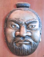
(Tuesday 17 August) Fearsome Mask of Acro-o (duplicate). Dedicated by Mitsukiyo Fujiwara to Kashima-jingu Shrine in Ibaraki in 1664. Courtesy of Mizusawa Research Center for Buried Cultural Properties. |
;) |
|
(Tuesday 17 August) Fearsome Mask of Acro-o (duplicate). Dedicated by Mitsukiyo Fujiwara to Kashima-jingu Shrine in Ibaraki in 1664. Courtesy of Courtesy of Mizusawa Research Center for Buried Cultural Properties. |
;) |
|
(Tuesday 17 August) Fearsome Mask of Acro-o (duplicate). Dedicated by Mitsukiyo Fujiwara to Kashima-jingu Shrine in Ibaraki in 1664. Courtesy of Courtesy of Mizusawa Research Center for Buried Cultural Properties. |
|
|
||
| Isawa-jo Remains |
|
North Mizusawa, Oshu City |
;) |
|
(Sunday 26 September) The "Torii" (Shinto Shrine Archway), Mizusawa Hachiman-jinjya Shrine or "Chinjyu-fu [naval station]-Hachiman-gu." |
;) |
|
(Tuesday 17
August) The first "Torii" (Shinto shrine archway), Mizusawa Hachiman-jinjya Shrine or "Chinjyu-fu [the military station and government office]-Hachiman-gu." Found in 801 by Tamuramaro Sakanoue and offered a wand with hemp and paper steamers to Hachiman, a Shinto god by Yoritomo Minamoto in 1189: Still holding Sakanoue's sacred sword and arrow with a turnip-shaped head that makes a sound as it flies as the shrine treasures. Located in the northeast edge of Isawa-jo Castle as Enryaku-ji Temple, Mt. Hiei to Kyoto, because the northeastern quarter was supposed to be the "demon gate" or an unlucky or a tabooed quarter in the ancient times. It is probably because the ancient Chotei (central government) always feared the Emishi or the people of the Tohoku District who often resisted against a number of their invasions.
There are so many Hachiman-jinjya shrines in Iwate because Hachiman is the shinto god of war or the Japanese Mars: it also the guardian god for the Minamoto clan who had fought with many "Emishi" and the local powerful families such as the Abe family, the Kiyohara family and the Oshu-Fujiwara family in Iwate and Miyagi. This Hachiman-jinjya Shrine had been especially worshipped and donated by famous samurai including Tamuramaro Sakanoue, Yoshie Minamoto, Yoritomo Minamoto, the Oshu-Fujiwara family, Hideyoshi Toyotomi and Masamune Date. |
;) |
|
(Tuesday 17 August) The second "Torii" (Shinto shrine archway) and "Hon-do" ("Main Hall"), Mizusawa Hachiman-jinjya Shrine. Shinto shrines normally has one "Torii" but this shrine has two "Torii" to show its authority. |
;) |
|
(Tuesday 17 August) Site of Isawa-jo Castle [Government Office]. Began to build in 801 and became the military station in 808: also functioned as a government office for about 150 years. Tamuramaro Sakanoue chose this location because it was near Aterui's headquarters and located between two big rivers, River Isawa and River Kitakami: easy of access and good for defense against enemies. The main building stood around here. |
;) |
|
(Tuesday 17 August) An information board of Isawa-jo Castle Site. |
;) |
|
(Tuesday 17 August) Site of Isawa-jo Castle [Government Office]. |
;) |
|
(Tuesday 17 August) An information board of Isawa-jo Castle Site. Characteristic of the two gates to show its dignity toward the local people. About 700 soldiers guarded this castle in turn. |
| CHRONOLOGY | |
| AD 776 | First reference to "Isawa" in the official record of Japan |
| 789 | First Invasion. Battle of Subuse (now east of Mizusawa, Oshu City), along River Kitakami: "Aterui" (first reported) beats the Chotei army. |
| 794 | Second Invasion |
| 801 | Third Invation. Tamuramaro Sakanoue leads the Chotei army. |
| 802 | Begins to build Isawa-jo Castle. Aterui and More surrender and are beheaded in Kawachi. |
| 808 | Isawa-jo Castle becomes the "Chinjyu-fu" (the military base and government office). |
| 862 | "Yakushinyorai-zazo" of Kokuseki-ji Temple was made. |
| 1053 | "Earlier Nine Years' War" (-1062) |
| 1056 | The "Akurigawa" Incident |
| 1057 | Yoritoki Abe dies. Sadato Abe wins at the Battle of Kinomi. |
| 1062 | "Earlier Nine Years' War" ends with the decline of the Abe clan. family. |
| 1083 | "Latter Three Years' War" begins (-1085). |
| 1105 | Kiyohira Fujiwara starts building Chuson-ji Temple. |
| 1124 | "Konjiki-do" (Golden Hall) of Chuson-ji Temple completes. |
| 1128 | Kiyohira Fujiwara dies at 73. |
| 1135 | Built Kosho-ji Temple, Inase Village, Esashi County. |
| 1170 | Hidehira Fujiwara becomes "Chinjyu-fu-shogun" (the generalissimo of the military base). |
| 1189 | Yoritomo Minamoto's invasion: the decline of Hiraizumi. |
For
further information of the region,
1. go to the "About" page.
2. go to the "Mizusawa" page.
3. go to the "Hiraizumi" page.
4. go to the "Hirakata, Osaka" page.
5. go to the "Kyoto East" page.
![]()
![]()